
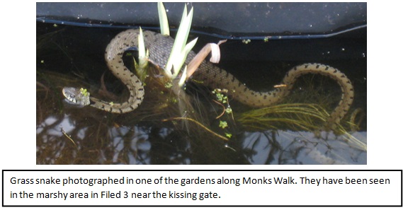
![]()
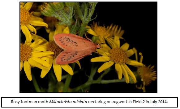
![]()
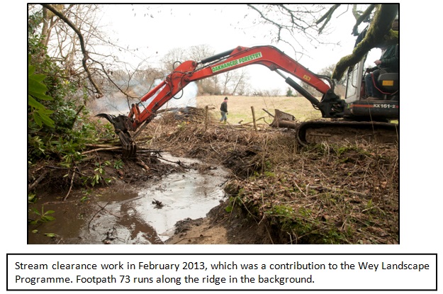
![]()
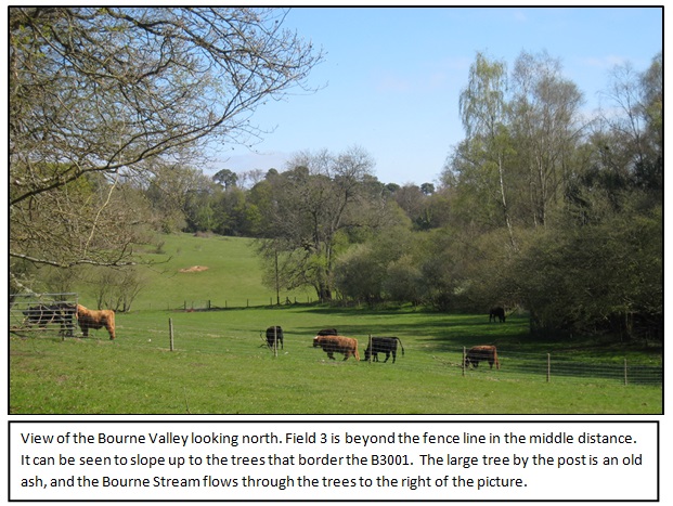
![]()
![]()
?
The Ecology of the Compton Fields
This report has been prepared by The Bourne Conservation Group (BCG), an entirely volunteer group that has been carrying out practical work in South Farnham since 2002 with the aim of maintaining and improving its landscape and biodiversity with due regard to its historical associations. Much of this work has been focussed in and around the valley of The Bourne Stream which is the central geographical feature of the area. Specific tasks have included footpath maintenance, woodland management and the eradication of Himalayan Balsam from the stream. In the course of this work members of the group have become very familiar with the scenic value and rich biodiversity of the three meadows known as Compton Fields and the nearby features which include patches of woodland and public footpaths. The report summarises the results of surveys carried out and sets them in the context of the heritage, landscape and Green Infrastructure of Farnham and the Wey catchment.
Executive summary
Based on detailed knowledge of the Compton Fields and surrounding area, attention is drawn to the concentration of different wildlife habitats in and around Farnham and the unusually rich biodiversity they support. The high number of local areas designated for the protection of individual species together with area?s overall diversity is indicative of this. Nevertheless, special measures, including the implementation of landscape scale conservation are required, to ensure the health and long-term survival of many native species which are vulnerable to natural disasters such as the heathland fires which have recently occurred in the area. Natural corridors like The Bourne valley are essential for the survival of these species.
Against this background, the Fields occupy a position of great significance to the landscape, ecology and heritage of south-east Farnham. Within 5 km of two Special Protection Areas, they are also close to the river Wey (classified as a Biodiversity Opportunity Area) and bounded by ancient woodland, hedgerows and a historic footpath. According to local knowledge the Fields have NOT been cultivated for at least 40 years and are hence classified as unimproved neutral grassland; this is a habitat of national importance according to the National Biodiversity Action Plan. They have generally remained untreated with chemicals for several decades, and hence support a rich diversity of animal and plant communities. The results of surveys (mainly in Field 3) are fully reported in this paper. They revealed a rich diversity of the plant and animal communities consisting of 126 species of higher plant, 20 species of lower plant, 38 species of fungi and 471 animal species ? an overall total of 655 species (this is an underestimate as not all the animal groups could be identified).
The introduction of a heavy grazing regime in Field 3 in 2013 has reduced the overt biodiversity but, if the grazing is relaxed, the seed-bank will allow it to recover. Amongst the plant species identified are 21 species of the grassland indicators which, under different circumstances, would alone qualify the fields to be seriously considered by the local authority as a Site of Nature Conservation Interest according to the published criteria.
The combination of this biodiversity and the focal geographical position they occupy, makes the Fields a valued part of the Green Infrastructure of Farnham. Not only do they provide habitats for a diverse range of flora and fauna but they are also stepping stones for the dispersal of wildlife along the Wey and Bourne corridors, and so are helping to link the open areas of the Surrey Hills Area of Outstanding Natural Beauty to the Alice Hold Forest west of Farnham and into Hampshire. They also contribute to the health and ?feel good? factor of the local community as they use the Boreas Dene footpath or travel on the B3001 road.
The designation, conservation and enhancement of Farnham?s green infrastructure (GI) is a key element in the Neighbourhood Plan which, after more than two years evidence-based work by a large number of individuals and groups in the town coordinated by the Town Council, is at a very advanced stage of development. This plan must be given serious consideration in the planning process. Registration of this GI provides a window of opportunity to arrest the loss of natural habitat that has been occurring. If this window of opportunity is missed then key aspects of the fabric of the local landscape and ecology will be lost.
1. Outline description of the Compton Fields
1.1 The sketch map shows the three fields are located astride the B3001 road at the South East corner of the built up area of Farnham. Fields 1 and 2 are relatively flat, whereas Field 3 is more strongly contoured and slopes down to the south and east to its boundary along The Bourne Stream. Local knowledge suggests that all three fields have only been used for light grazing by horses for at least 40 years and have not been subjected to any chemical treatments, however, in mid-2013 Field 3 was fenced and has been grazed heavily by cattle, and some chemicals have been applied, specifically to control the nettles.
2. Their Environmental Setting
2.1 The Position of Farnham. Farnham is uniquely situated at the western end of the Weald of Kent, Sussex and Surrey, so that its underlying geology changes over unusually short distances. As a result the town is surrounded by an exceptionally rich assortment of habitats, ranging from sandy heathland and clay woodland to chalk down-land, which together support a mix of ancient woodland, grassland and park-land. Further variety is contributed by the floodplain of the river Wey. As a result, the town and its environs are home to an unusually rich diversity of wildlife. There are, for example, some very rare species of plants growing near the fields, and in the immediate neighbourhood our own group has recorded 594 species of moths (247 species of micromoths and 347 species of macromoths) which amount to over 25% of the UK?s moth fauna. This exceptional biodiversity has resulted in the designation of a large number of sites near the town to protect both individual species and the area?s overall diversity. The landscape also has high intrinsic value as indicated by the boundary of the Surrey Hills AONB tracking through South Farnham and abutting on the Compton Fields. Nearby there are two Sites of Special Scientific Interest (SSSI), and the River Wey is a designated chalk stream. Development in the town has already had to comply with the environmental regulations governing developments near the Thames Basins Heath Special Protection Area (SPA) and the more recently established Wealden Heaths SPA.
2.2 Designated Protected Areas. The designation of Special Protection Areas (SPAs) principally targets the protection of individual species such as sand lizards, nightjars and the Dartford warbler. However, there is growing concern that even many of the more common native species are in serious decline as a result of habitat loss, pollution, climate change, competition from aggressive alien species and other factors. These declines have been highlighted in national publicity focussing on the critical states of many of our insect pollinators; their declines are sufficiently serious to 

threaten not only the richness of our biodiversity but also the sustainability of agricultural production. As a result a more systematic approach to conservation is being adopted to ensure development is sustainable environmentally as well as economically and socially as set out in:
https://www.gov.uk/government/uploads/system/uploads/attachment_data/file/409430/Summary-responses-national-pollinators-strategy.pdf
From these consultations has emerged a new approach ? ecosystem or landscape-scale conservation. The principle objective of this approach is the harmonisation of sustained economic and social development with the needs of the natural environment and our native wildlife. A successful landscape approach is critically important in the South-east of England where large building quotas have to be met by local authorities as the human population increases. If a sustainable balance cannot be achieved between the demands for housing, development and infrastructure then our natural heritage will be eroded and the quality of life for the population will rapidly decline. To ensure this landscape approach is effective, Biodiversity Opportunity Areas (BOAs) have been identified by the Wildlife Trusts working in collaboration with local government and other central authorities including DEFRA and English Nature.
2.3 Wildlife Corridors. Wildlife corridors are a fundamental component of landscape scale conservation. The valley of the river Wey provides such a corridor, and it has been designated a Biodiversity Opportunity Area partly because it acts as a green corridor through urban Farnham, but also in response to the Water Framework Directive and the need to sustain the quality of water supplies. Green corridors provide important environmental services whereby populations of species that have been hit or even locally eradicated by natural or man-made disasters have the means to recover. The massive heathland fire on Frensham Common in 2010, serious flooding in the lower Wey valley in 2013 and large fires on the Pirbright Ranges and in the Gong Hill RSPB reserve in early 2015, all exemplify local incidents that can result in extinctions. A single narrow green corridor will not ensure the recovery of the full range of wildlife in the area, but the Green Infrastructure (GI) which consists of the network of semi-natural open spaces, gardens, hedges, woods, rivers and streams will enable species to pass through the inhospitable expanses of brick, concrete and tarmac. These features are all important components of the GI that underpins the landscape approach and will complement the essential human infrastructure that insures human health and well-being. The Surrey Wildlife Trust is exploring the possibility of establishing Farnham as one of the first urban BOA?s in the country.
2.3 Farnham?s Green Infrastructure. A partial network of GI consisting of open spaces and patches of woodland already exists within the built up area of Farnham. In The Bourne, these features are inter-connected by a unique network of footpaths, including Boreas Dene (FP 73) which bisects the Compton Fields. Many of these footpaths are ancient rights of way that continue to be well used, and thus are playing a key role in maintaining the health of the human population and ensuring the neighbourhood remains a good place in which to live. They also link otherwise isolated communities of plants and animals communities preventing them from becoming isolated and hence vulnerable to extinction. This combination of the footpath network and open spaces fulfils a number of functions. It makes a significant contribution to the local ?feel good? factor and is helping adults and children to stay connected with nature. Together with the wildlife that is present, it provides recreational and educational opportunities. The trees and hedges absorb aerial pollutants (a critical problem in Farnham), muffle noise and reduce the intensity of the urban heat dome (conurbations can be several degrees warmer that the surrounding countryside and can result in physiological stress during heat waves). Private gardens complement the GI network; in 2012 BCG ran a local garden questionnaire which elicited over 100 responses revealed just how important gardens are in supporting local biodiversity, however, if connectivity is lost they will become ineffective.
2.4 Environmental resilience. Our environments (both natural and human) have to be sustainably managed. This will only be possible if they are kept resilient to the impacts of future changes. There are a number of significant environmental changes afoot, which have been widely reported on. BCG has recorded the impact of some of these during its work in The Bourne.
Foremost is climate change. We have observed marked changes in ?phenology? – the seasonal times when trees leaf out, spring flowers like snowdrops bloom and birds start nesting. The general trend has been for these events to occur progressively earlier, but superimposed on this general trend is an increase in unpredictability. For example the cold Spring of 2013 bucked the trend and had marked knock-on effects on the viability of insect pollinators and the breeding success of birds. One of the factors contributing to the population decline in cuckoos, those harbingers of summer, has been attributed to a decline in the numbers of the caterpillars of large moths, which are the staple diet of the adult birds. New species have been arriving in our area, mainly from Europe. In the last five years, BCG has recorded in the Compton fields the arrivals of the ivy bee, Colletes hederae, the tree bumblebee, Bombus hypnorum, and the landhopper, Arcitalitrus dorreini. Conversely the serious declines of some of our native species, such as the honey bee, the house sparrow, the starling and the song thrush, have been widely reported. The full impact of these changes is yet to be assessed but they seem to be contributing to the success of invasive alien plants like Himalayan balsam and Japanese knotweed. Both of these invasive species were abundant along the Stream in Field 3, but are now under control as a result of BCG?s work in cooperation with the tenant farmer. These are plants that pose serious threats not only to our native plants but also, in the case of Japanese knotweed, to the very fabric of our structures. A few plants of Japanese knotweed still persist along the Bourne Stream in Field 3, and it is still growing profusely by the stream just a few yards downstream of the Monks Walk Bridge.
Another unpredictable factor is the spread of the tree diseases, which are infecting ash and oak trees. When the hedge along the B3001 was re-surveyed in January 2015, there were clear signs of the impacts of the last serious tree disease – Dutch elm disease which in the 1970?s radically altered the British landscape. The new diseases may prove to be even more drastic. These changes are already afoot. So a fulsome green infrastructure that includes the Compton Fields is needed to endow our natural fauna and flora with the resilience needed to withstand the impacts of these invasions. It will also help combat air pollution. Farnham already suffers some of the highest concentrations of nitrous oxide in the country; a problem which can only get worse if the traffic increases and the loss of trees and green spaces continues.
3. The Focal Position of the Compton Fields The geographical location of the Compton Fields is in an area of great significance to the landscape, ecology and heritage of south-east Farnham.
3.1 Heritage. Historically the natural resources provided by the landscape supported a thriving human population. Mesolithic axe heads have been found in The Bourne Valley and there are remains of a Roman pottery kiln adjacent to Field 1. Less than a kilometre away are the ruins of Waverley Abbey, Mother Ludlam?s cave which was home to an old tinker lady in the 17th Century, and Moor Park House, which was regularly visited by Charles Darwin. The former tracks and paths which linked these sites with the Saxon settlement of Farnham have been replaced by modern-day roads, but the Boreas Dene footpath (73) which used to link Green Hill Farm and Waverley Abbey Farm and today bisects fields 2 and 3 probably remains in very much its original condition.
3.2. Ecology. From the ecological standpoint the Compton Fields are:
?Within 5km of the Thames Basin Heaths and Wealden Heaths SPAs and linked to them through the GI network
?Close to the river Wey Biodiversity Opportunity Area including the Moor Park alder carr SSSI
?Bounded in the South-east by The Bourne Stream.
?Bounded by ancient woodland on two flanks and is separated from Compton Copse by a narrow lane and the B3001.
?Close to the two SNCIs along the Monks Walk road
?Field 1 is bounded by an important ancient hedgerow along the B3001
These are all environmental elements that form the building blocks of a living landscape. They are contributing a wide variety of natural habitats: wetland, woodland and grassland, together with the low density urban environment of South Farnham. The removal of any one of these elements will seriously and irrevocably impair the landscape. Furthermore these remarkable habitats support a rich diversity of local wildlife. On a larger scale it broadens the natural corridor of the river Wey, and provides a stepping stone along the wildlife corridor of The Bourne Valley that links the Wealden Heath SPA and the Thames Basin Heaths SPA with the Woodland of Alice Holt Forest. The Fields are an important component in the maintenance of these ecological hotspots and should remain so. The recent fires on the Pirbright Ranges and on the Gong Hill RSPB reserve illustrate just how important it is to maintain the green corridors, which ensure the diversities of these key areas can recover from similar future disasters.
4. Summary of BCG?s Practical Work and Surveys
4.1 Practical Work. Since its foundation in 2002 BCG has regularly worked in the general area of Compton Fields (see Table 1). Initially this was in support of Surrey CC in maintaining the Boreas Dene footpath, but was later extended to woodland management tasks for Waverley BC in Compton Copse. In 2005 work started on the eradication of Himalayan Balsam from The Bourne Valley, starting near Rowledge and working downstream. In 2009 this clearance reached the fields belonging to Redhill House and thence extended into Field 3, which has continued to be checked each year.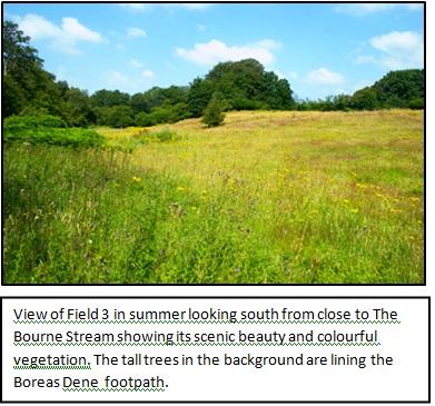
During the unseasonally dry spring of 2012 a survey was carried out of The Bourne Stream between the Monks Walk Bridge and Redhill House, which revealed just how neglected the Stream was, choked with fallen trees and contaminated with fly-tipped rubbish. As result of this survey in February 2013 funding was secured from the Community Chest of South East Water to carry out a major project of tree management and litter clearance, primarily focused along the stretch of The Bourne Stream alongside Field 3. This was a contribution to the Wey Landscape programme which is being coordinated by the Surrey Wildlife Trust on behalf of the Environment Agency which is charged with fulfilling the Government?s obligations under the EU Water Framework Directive to improve water quality in the Nation?s waterways. This local project work thereby contributed to the improvement of the water quality of the River Wey.
A list of all maintenance work carried out by BCG is presented in Table 1
Table 1 List of BCG working parties in and around Compton Field (2007-2015)
DateLocationsTasks11/Nov/2007Compton CopseWoodland maintenance6/June/2008Bourne ValleyBalsam pulling21/Sept/2008Footpath 73Footpath maintenance14/June/2009Bourne Valley/Redhill HouseBalsam pulling31/July/2009Compton FieldBalsam pulling7/Aug/2009Compton FieldBalsam pulling4 July/2010Bourne ValleyBalsam pulling4/Oct/2010Bourne Valley FP 73Ancient tree survey7/Aug/2011Bourne valley/Compton FieldBalsam pulling31/Mar/2012Bourne StreamSurvey of stream status1/June/2012Bourne Valley/Burrows DeneBalsam pulling3/June/2012Bourne Valley/Burrows DeneBalsam pulling9/Oct/2012Bourne StreamInspection with D. Environment18-21/Feb/2012Compton FieldClearance work with contractors29/April/2013Compton FieldBotanical Survey with Surrey Botanical Group12-14/May/2013Compton FieldHand pulling of ragwort7/July/ 2013Bourne Valley and FP 73Balsam pulling, footpath$ maintenance25/July/2013Compton FieldBalsam pulling, litter clearance23/Aug/ 2013Compton FieldBalsam pulling, litter clearance18/Dec/2013Compton FieldRemoval of barbed wire etc10/Aug/2014Redhill HouseBalsam pulling11-12/Jan/2015B3001 by fieldsAncient Hedge Survey
4.2 Surveys. Having recognised the rich diversity of Field 3 during the Himalayan Balsam clearance, wildlife observations and surveys were begun there. Most of these surveys have focussed on Field 3 and along The Bourne Valley. Nightime surveys of insect visitors to ragwort were carried out in 2013 and 2014 in both Fields 2 and 3. No systematic surveys have been carried out in Field 1, except for the re-survey of the ancient hedgerow between Field 1 and the B3001 in January 2015. The survey results recording of over 650 species (over the last three years) are listed in Table 3 in the Annex.
5. Description of Field 3 and the Boreas Dene Footpath
Field 3 generally slopes from the top gate in the north-west corner (close to the junction between the B3001 Road and Old Compton Lane). The valley landscape from the gate presents a secluded aspect that has considerable appeal especially in summer when the meadow flowers are in full bloom. The blackberries in the top part of the field offer some of the richest pickings in the neighbourhood. The soils are sandy and generally well drained. In the southern area there is a land drain from Field 2 running down a small re-entrant and emptying into The Bourne stream which forms the southern boundary of the field. Despite this drain the public footpath gets extremely muddy in winter.
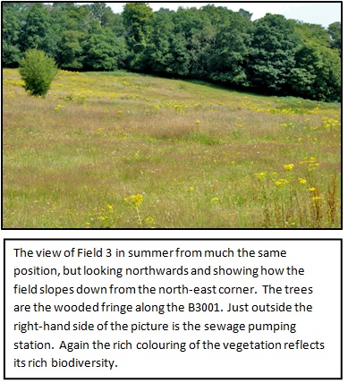
A major underground sewer runs alongside the stream to the pumping station in the north-east corner of the field. This pumping station is already operating at close to, or over, its maximum capacity; for example during the 2013 winter its emergency overflow was discharging for several weeks into the Stream, and thence into the River Wey (there are pictures available illustrating this discharge). Recently, there has been at least another similar incident when for several days the sewage had to be carried to the sewage works by road tanker. The addition of the out-pourings of another 156 houses will exacerbate this serious situation.
Along the steep side of the valley opposite the field is an area of unregistered land that is classified as ancient woodland, another irreplaceable ecological feature. There are some fine mature trees, which include several large beech, oaks, and a scattering of silver birch and hornbeam. However, the woodland has been heavily invaded by rhododendron which has overwhelmed the ground flora, and is in urgent need of control.
To the north, the Field is bounded by a narrow strip of woodland (partly owned by SCC), which is growing on an old gravel pit. This woodland effectively secludes the field from the B3001 road, and although this wooded strip contains some rather poor trees it does include some fine mature oaks and hornbeams. This wooded strip is a link with the woodland of Compton Copse across the road.
Along the southern margin of the field on the floor of the valley is an open pasture, which is part of the Redhill House estate and currently used for grazing cattle and dog walking.
Along its western edge is footpath 73 (Boreas Dane). This is an old path that, in the 19th and early 20th centuries, linked the farms around Waverley Abbey with Greenhill Farm and the hamlets of the upper Bourne. Today the footpath is well used by walkers and joggers. It is regularly maintained by BCG members who are registered footpath wardens for SCC. The footpath is lined with ancient, ivy clad oaks. These oaks were registered in 2001 as trees of interest in the Woodland Trust?s national inventory of ancient trees. Being ivy covered these trees are well used by nesting birds and roosting bats. There are also stands of hazel, hawthorn and some dog rose along the field side, as well as occasional specimens of blackthorn and wild cherry.
At the top north-western corner of the field is a patch of bracken and several clumps of bramble thicket. These thickets were centres for a rich insect community but have been mechanically cut back since the introduction of grazing. Towards the centre of the field there were patches of nettle associated with some of the thickets, but these have subsequently been sprayed. There are isolated hawthorn trees and dog rose bushes. The highest plant diversity is associated with the warm well-drained south-facing slope in the southern quarter of the field. The steepest slopes form an arc extending from just above (and west of) the pumping station and curving around to the footpath just to the north of the kissing gate in the southwest corner. On the field side of the stream are several hazel coppices and it was in these wet areas that there were dense stands of Himalayan balsam growing in amongst the bracken. There were also some large stands of Japanese knotweed. The field itself is well used as a foraging area by bats.
6. The Ecology of Field 3
BCG first began to undertake wildlife surveys in Field 3 in 2009 which was when its Himalayan Balsam clearances had reached this sector of The Bourne valley. A very large patch of Japanese knotweed was noted plus several smaller patches both upstream and downstream.
The field proved to be very rich floristically, but was being invaded by bracken and scrub. In summer profuse stands of ragwort turned the field golden. Interspersed between the ragwort were colourful floral displays of germander speedwell, vetches, knapweeds, common mallow, goat?s beard, scarlet pimpernel, yellow-wort, centaury, and hawkweeds. The surveys revealed the presence of 21 species of grassland indicator species; more than enough for the field to qualify to be designated as an SNCI.
This rich flora supported an impressively diverse community of invertebrates especially where there was high structural diversity associated with the bramble and hazel thickets. The profuse growths of ragwort were providing rich sources of nectar in late summer. Even recently in the summer of 2014, night-time visits to Field 2 when the ragwort was in full flower yielded records of 31 species of moth feeding on the nectar, and by day there was a similarly diverse but different fauna exploiting the flowers. In the autumn investigations of the ivy flowers on the trees along the footpath yielded records of eleven more moths by night and numerous butterflies, hoverflies and ivy bees by day. On 24th July 2014 the remaining nettle patches in Fields 2 and 3 were covered with a mass of peacock and red admiral butterfly caterpillars and there were dozens of small tortoiseshell butterflies flying and mating around the nettle and bramble patches. Despite the heavy grazing of Field 3, which started in the summer of 2013, sharply reducing the obvious floral diversity, the insect diversity remains high. At present there will be an ample viable seed bank to enable the full floral diversity to recover if the grazing pressure is relaxed.
So today, the field is unimproved neutral grassland, which has not been cultivated, as far as we know, for at least 40 years and so according to the National Biodiversity Action Plan, is a habitat of national importance. Because it has generally remained untreated with chemicals for several decades, it supports a rich diversity of animal and plant communities. While few of the identified fauna and flora are of special conservation importance, its rich assemblages of species are important; no comparably rich communities are to be found within many miles. However, it is noted that the flora identified in 2012 and 2013 included 21 species of grassland conservation interest (see table 2). These species may no longer be clearly evident because of the heavy grazing, but will soon recover from the seed bank if the grazing pressure is relaxed. This year pignut is still growing in the fenced off margin bordering the Bourne Stream. In Annex A the complete inventory of species recorded (in excess of 650) in Field 3 is listed. Over 250 of these species have been recorded photographically. All records have been submitted to the Surrey Biodiversity Data Centre. Despite its impressive length, the list probably represents less than half the species present, since it has not been possible to identify the species of several diverse groups which require specialist expertise (e.g. snails, beetles, spiders, mosses and lichens). This listing shows that the field is not only a beautiful green space but is also a highly diverse area of considerable ecological merit.
Table 2. Plant species of grassland conservation interest
Scientific nameCommon nameYear recordedAngelica sylvestrisWild angelica2013Anthoxanthum odoratumSweet vernal-grass2013Blackstonia perfoliataYellow-wort2012Centaurium erythraeaCommon century2012Conopodium majusPignut2015*Hieracium agg.Hawkweed species2012Knautia arvensisField scabious2012Lathyrus nissioliaGrass vetchling2012Lathyrus pratensisMeadow vetchling2013Leucanthemum vulgareOxeye daisy2012Lotus corniculatusCommon bird?s foot trefoil2013Odontites vernusRed bartsia2012Pilosella officinarumMouse-ear-chickweed2013Poa pratensisSmooth meadow grass2012Potentilla erectaTormentil2012Potentilla sterilisBarren strawberry2013Primula vulgarisPrimrose2013Rumex acetosellaSheep?s sorrel2013Stellaria gramineaLesser stichwort2013Tragopgon pratensisGoats-beard2012Valeriana officinalisCommon valerian2013
It is also noteworthy that in the SNCIs along Monks Walk adjacent to the strip of ancient woodland, the Surrey Wildlife Trust has recorded several nationally rare species of wild flowers. Although to date none of these species has been recorded in Compton Field, there is a possibility that these rare species will be able to extend their ranges into them if some protection can be afforded to the fields.
7. Description and Ecologies of Fields 1 and 2
7.1 Field 1. We have not surveyed field 1 apart from the surveying of the hedgerow bordering the B3001. The field has been used for grazing horses for many years and their wintertime supplementary feeding will have raised its nutrient status. In summer ragwort grows there in some profusion and is likely to be a significant nectar source for pollinators. The hedge was re-surveyed in January 2015. It is populated by many woody species including hawthorn (Crategus monogyna), oak (Quercus robur), ash (Fraxinus excelsior), sycamore (Acer pseudoplatanus), goat willow (Salix caprea), English elm (Ulmus procera), spindle (Euonymus europaeus), privet (Ligustrum vulgare), dog rose (Rosa canina), and blackthorn (Prunus spinosa). Other species may have been present that we were unable to identify in winter, even so since it is supporting at least eight woody species per 30m.
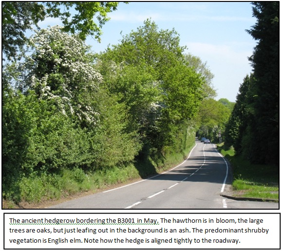
So it is an ancient species-rich hedgerow, which according to the national Hedgerow Biodiversity Action Plan, should be given full protection. (www.hedgelink.org.uk).
7.2 Field 2. Again, this field has not been surveyed this field in the same detail as field 3. To the north it is bounded by the rather gappy, but species-rich, hedge along the B3001. Along its eastern boundary is a two to three strand barbed wire fence that kept the stock from straying into the line of trees along the steep bank that borders Footpath 73. This fence-line is reinforced with clumps of bramble. The fence line dips down to the south into a shallow valley which drains the southern end of the field and in winter becomes very boggy. The southern boundary is marked by a well maintained fence line that borders an area of ancient woodland. The western boundary follows along the boundaries of the gardens of the houses along Abbot?s Ride.
In summer there are profuse stands of ragwort which attract a high diversity of insect pollinators. At night over 30 species of moth have been photographed feeding on the flowers. Generally the flora appears rather scruffy and somewhat species poor, but this may be more a function of a lack of survey rather than a true reflection of its actual diversity. There are some surprises, for example the wet ?valley? at the southern end of the field is the only known site for wild orchids in The Bourne.
8. Multifunctional value of the Compton Fields as Green Infrastructure
The focal position occupied by the Compton Fields, combined with their inherent biodiversity and attractive landscape greatly enhances the importance of their contribution to the Green Infrastructure assets within the town boundary of Farnham. There are many facets to these values as set out below.
8.1 Biodiversity. The rich diversity of the fields is comprehensively demonstrated by the fulsome list of species in Annex A. All these records have been submitted to the Surrey Biodiversity Records Centre, and the species continue to be regularly monitored.
8.2 Landscape. Field 3 is a scenically beautiful ecological unit flanked by the ancient woodlands that line the eastern slope of the valley, the line of ancient trees that line the footpath and the fringe of woodland lying along the field boundary between the Elstead Road (B3001) and the boundary.
8.3 Recreation. The footpath (73) is in regular use by walkers and joggers. It represents a safe out-door recreational environment for visitors of all ages.
8.4 Education. The field has considerable potential for educational use, which is yet to be realised. The head master of Barfield School has expressed an interest in using the field for environmental studies, and the field is close to several other schools such as the South Farnham School, St Polycarps and Farnham College.
8.5 Wey Landscape Programme. The recent improvements to the status of the Bourne Stream will have made a contribution to the water quality of the river Wey. Under this programme links have been established both with local community groups, such as the Farnham Rivers Group, and county-wide groups (e.g. SWT and the National Trust), Government department and Water companies.
8.6 Wildlife Corridor. The field represents the initial stepping stone of a significant wildlife corridor along the valley of The Bourne stream, which passes through the urban area of South Farnham and links the Wey Valley to Bourne Wood to the east and Alice Holt Forest (Hampshire) to the south.
8.7 Biodiversity Action plans. The designation of this field as green infrastructure would serve one of the key objectives of the Surrey Biodiversity Plan and the Urban Diversity Action Plan, in making the boundary to the outskirts of Farnham ?permeable to wildlife?, and acting as a buffer zone between the open countryside along the Wey Valley and the spread of urban Farnham.
9. Conclusions
The Compton Fields provide important habitats for a diverse range of flora and fauna. They are stepping stones for the dispersal of wildlife along the Wey corridor, and so are helping to link the open areas of the Surrey Hills Area of Outstanding Natural Beauty to the similar areas west of Farnham and into Hampshire. They not only form a closely integrated part of the living landscape of south-east Farnham but have strong heritage associations going back to the earliest times.
The fields amply fulfil the majority of the criteria required to be designated as Green Infrastructure (GI), both in a local and in a county-wide context. This proposal is supported by a wide partnership of voluntary and statutory bodies. So far expressions of support have been received from the Surrey Wildlife Trust, the Surrey Botanical Society, local Residents Associations and the Farnham Rivers Group.
At the local level, the designation of areas contributing to Farnham?s green infrastructure is a key element in the Neighbourhood Plan which, after more than two years work by a large number of individuals and groups in the town coordinated by the Town Council, is at a very advanced stage of development. The Surrey Wildlife Trust landscape section has contributed to this effort and has taken it a stage further by identifying the fields as part of The Bourne Stream green corridor linking the Surrey Hills AONB and river Wey to Alice Holt Forest.
Farnham?s unique geographical position endows it with an exceptionally rich assortment of wildlife habitats but these are under threat for a number of reasons including the steadily rising amount of urban development as the population approaches 40,000. There is at present a one-off window of opportunity to arrest this loss of habitat that is affecting many wildlife species by giving long-term protection to key areas that the local community has recognised are important for its health and well-being. If this window of opportunity is missed then key aspects of the fabric of our local landscape will be irreparably lost.
Acknowledgements We gratefully acknowledge Mr Andrew Ward and Mr Greg Salder for allowing us to access their land. We must also thank the many people have helped with the surveys especially Graham Collins, Jovita Kaunang, Dr Catherine Burton, Isobel Girvan, Sue Cooper and many members of the Bourne Conservation Group.
Martin Angel and Noel Moss
The Bourne Conservation Group
May 2015
Biographical notes on the authors
Martin Angel MA PhD initially qualified in Natural Sciences at Magdalene College Cambridge. After gaining his PhD in Zoology at Bristol he became a biological oceanographer at the National Oceanography Centre and became head of the Biology Group. He was Vice President of the British Ecological Society (1980-2) and served on the Steering Group that drew up the UK?s Biodiversity Action Plan (1984-6). Since his retirement in 1997 he has been developing his expertise and knowledge of the ecology of the local fauna concentrating particularly on the area?s moths. He is an active recorder for the Surrey Wildlife Trust.
Noel Moss C Eng, FIEE, FI Mgt served a full career in the Army before settling in Farnham where he became a founder member of The Bourne Conservation Group. First as secretary and from 2006 as chairman he has applied himself to the logistic and liaison aspects of conserving and enhancing the biodiversity of The Bourne valley. Since 2007 he has also been chairman of the Farnham River Management Committee that draws together all agencies with responsibilities towards the management of local flood risk and other matters.
ANNEX A
Full Species List
This is a full listing of the plant and animal species recorded in 2012-2014 (mostly from the field 3). Those plant species which are of particular conservation interest (as listed in Gibb, C. (ed.) 2008. Guidance for the selection of Sites of Nature conservation Importance in Surrey (SNCI)), are highlighted. Note, despite its length this list is far from being fully comprehensive taxonomically, nor can the invertebrate species of conservation interest be identified.
To view the Full Species List click here. ![]()
All content ? Bourne Conservation Group 2008