The Bourne Stream
Bourne is an Old English word for a seasonal stream and as its name indicates The Bourne Stream is one such seasonal water course. It is usually dry in the summer months and in full flow in winter, but this is dependent on rain fall, for example it was also dry in the winter of 2012. The stream rises in the forested area of Alice Holt Forest and flows through the urban area of South Farnham before joining the River Wey between Compton and Waverley Abbey. Its surface water catchment is approximately 7km long by 1km wide. Although the stream is of small size it has been classed by the Environment Agency as a Main River since 2006 and flows in a significant, steep-sided valley which is the dominant geographical feature of South Farnham. It is not surprising therefore that it has been a major influence on the activities of our Group. This has included work on the stream itself including a long term project to keep invasive plant species under control, a great deal of effort on maintenance of footpaths alongside the stream, and regular work on sites in the valley such as the Underdown Nature Reserve. One major clearance operation took place in 2013 along the stretch through Compton Fields. Details of this work programme are given later.
Underlying Geology
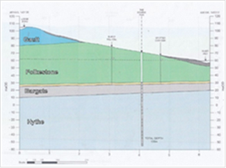
The diverse landscape of Farnham arises from its unique underlying geology that exposes the whole range of Wealden strata in a small area. Of these, in South Farnham, it is the Gault Clay and Lower Greensand that predominate: the Stream rises in the Gault Clay of Alice Holt but thereafter flows over Lower Greensand. This consists of a number of distinctive layers named after the places where they were first identified (mainly on the coast of Kent). The two main ones of relevance here are the Folkestone and Hythe beds, both of which are aquifers that hold important water supplies. The Bargate bed is also present and that was once quarried for building stone in the Churt – Godalming area and used in both the original and present churches of St Thomas-on-The Bourne.
The other feature of local significance has been the layer of gravels over-laying those much older strata on the hill tops. This drift material was deposit by river action in comparatively recent geological time as the present river systems were formed. This involved both the main rivers that flow in Farnham in a process known as River Capture by which the headwaters of the Blackwater were stolen by the Wey. This affected all their tributary streams some of which disappeared while others were left flowing in valleys out of all proportion to their flow. This explains why The Bourne valley is like it is.
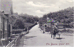
The gravels were extensively quarried both by local residents and commercially in the nineteenth century when they were mainly used as ballast for railway lines. The deepest seam was on Gravel Hill. Their long term significance, however, is that important finds of early human artefacts were made in some of the gravel pits including for example large stone hand axes at Gravel Hill and in Wards Pit on which the present church of St Thomas stands. The Revd Griffith, second Vicar of The Bourne Parish, was involved in the research on these implements.
The local geology helps to explain the seasonality of flow of The Bourne Stream flow. The sandstones mentioned are permeable with the result that the water table is deep below the surface so, unless there is high rainfall, the stream dries. This meant that when wells were a normal source of water for households, they had to be dug deep in this area. The first Vicarage of The Bourne on Vicarage Hill had a well of depth 45m but this still ran dry and had to be deepened.
Modern Water Supply and Drainage
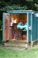
A modern piped water system for central Farnham was provided after about 1900 when the Victoria Reservoir came into use. Even so, it was several decades before the out-lying villages were connected to a mains supply. Thus, The Bourne was not connected to a mains supply until 1920 when a borehole was sunk at Tilford Meads. This situation continued until the 1960s when a new borehole was sunk alongside The Bourne Stream at Sturt Walk from where the water is still pumped up the hill to the reservoir. For a time this provided all of Farnham’s water but gradually the various systems have been connected together to provide flexibility in the supply. The diagram shows the Sturt Walk borehole with a depth of 134.1m and illustrates the Lower Greensand strata already referred to.
The Bourne Valley also plays a major part in the disposal of waste waters and sewage. A main sewer underlies the Valley from Rowledge to Waverley Lane where there is a Pumping Station that pumps the flow to the Sewage Works at Water Lane for treatment. A feature of concern is that during periods of high rainfall the water company is legally permitted to discharge untreated sewage into the Bourne Stream and thence into the River Wey, thereby compromising the water quality of the rivers. The new building in our area is increasing these flows of waste waters.
The Watercourse
The Stream and its valley will now be described in three sections:
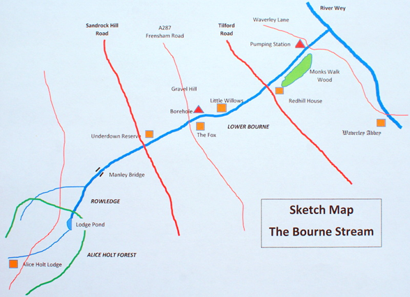
- From the source in Alice Holt to Sandrock Hill Road. Including the Lodge Pond. This is a predominantly rural area with woodland and farmland, for example near Manley Bridge, but some Rowledge properties are close to the stream.
- From Sandrock Hill to the Tilford Road. Although there are some open spaces in this sector, it is largely urban in aspect and becoming increasingly so. Originally, the stream gave its name to the three hamlets of Upper, Middle and Lower Bourne. The first two are now only remembered by street names but Lower Bourne survives as a thriving village community and the general area is known as The Bourne. There are many riparian owners whose land adjoins the stream and they have responsibility for maintenance of their banks.
- From Tilford Road to the River Wey. Once again this is a rural sector with the stream flowing through the Redhill House estate and between a large meadow, which is part of the Compton Fields site, and Monks Walk Wood. The final stretch is through pasture between Waverley Lane and the confluence with the Wey.
These reaches will now be described in more detail.
Section 1: Alice Holt to Sandrock Hill Road
The source of The Bourne Stream is often described as being the outflow of the Lodge Pond but this is not entirely true. There is another a small stream feeding the pond that rises to the west of theA325 at Bucks Horn Oak close to Alice Holt Lodge, and another stream which drains the Holt Pound Enclosure which joins the mainstream below Lodge Pond. Lodge pond is artificial and is presently maintained by the Forestry Commission for recreation and fishing. Its dam regulates the water level via a 0.75m diameter pipe. In a short distance downstream is another smaller pond that probably originated as a nineteenth century clay pit. At Holt Pound the flow is joined by the small tributary that drains west of the A325. The joint flow then goes through the lightly built-up and alongside Browns Walk to Sandrock Hill Road. Along this stretch the stream bed leaves the Gault Clay and flows over the Greensand which is where the water table sinks so the stream becomes more prone to drying out. There are however a few springs that feed a little water in at some points even in very dry weather.
Section 2: Sandrock Hill to the Tilford Road
This sector is more heavily urbanised although the well wooded valley with its many gardens and hedges retains its rustic charm. The watercourse here has been heavily modified by successive works to alleviate flood risk for homes and businesses. The latest of these was its small re-alignment along Sturt Walk necessitated by a landslip from the Old Church Lane hillside on Christmas Day 2012. From Sandrock Hill a footpath runs alongside the stream which is the start of a comprehensive network of paths and bridleways in this part of the valley. These originated in the 19th Century from the needs of local residents to gain access to water and to the many small gravel pits being worked there. On the main path close to Sandrock Hill, is the entrance to Underdown, the smallest of the Surrey Wildlife Trust’s nature reserves. There is no direct access to the stream in the middle of this section where there are privately owned meadows. However, downstream of Ford Lane access is restored and extends beyond the A287 at the Fox public house, a grade 2 listed building. Along this stretch the stream banks were open and heather clad and were home to a notable colony of Great Green Bush Crickets which sadly disappeared in the 1990s, possibly due to sewer construction works in the valley. Beyond the A287 the stream-side path continues as Sturt Walk which passes the bore hole opposite the Fox and the picturesque Willow Cottage. This is a locally listed building that was once the home of Fred Grover who featured in the books of local historian George Sturt as Fred Bettesworth, the Surrey Labourer. The path then turns uphill and becomes the Switchback Path, which passes Lake Cottage – a reminder that there was once a seasonal lake in this part of the valley – and then a small patch of common land known as Little Switzerland. The path then joins the metalled Bourne Grove. Here the Stream flows in a trench alongside the road passing the Spotted Cow public house and a small estate. This was built on the site of an old commercial site that may have been the source of the invasive Japanese knotweed that is now a scourge in the lower valley.
Section 3: Tilford Road to the river Wey
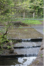
The Tilford Road crosses a bridge over the stream and a concrete slope which prevents the upstream migration of riverine fish like the bullhead into the upper reaches of the Stream. Beyond the bridge. is a most attractive sector of the valley with a rural mix of woodland and pastures which are used for grazing sheep and cattle. A public footpath path runs along the valley between the Tilford Road and the B3001 Waverley Lane. This is an ancient path known as Boreas Dene which linked the farms along what is now Greenhill Road with the farms near Waverley Abbey. The land to the south of the path is part of the Redhill House estate and includes the strip of woodland, known locally as Monks Walk Wood, which is designated Ancient Woodland. Sadly, it is in dire need of conservation effort as it has become overrun with rhododendron. Likewise, the stream bed has become invaded by Japanese Knotweed and but for 15 years of effort by the Bourne Conservation Group would now also be totally overrun by Himalayan Balsam. At the junction of Waverley Lane and Monks Walk the main South Farnham sewer enters the pumping station. The stream briefly disappears into private land behind the extraordinary North Lodge house, before crossing under Waverley Lane and flowing across the pastureland belonging to Moor Park House to its confluence with the River Wey which is thought to be a fish spawning site.
The Bourne Conservation Group’s Work in The Bourne Stream Catchment
Footpaths
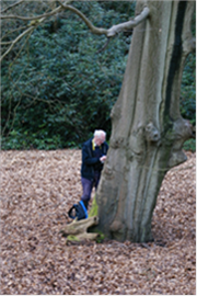
Soon after it was formed our Group became acquainted with the Stream through maintaining the footpath network. This drew our attention to any blockages in the Stream and problems of keeping the embankment safe as for example on the path opposite the Bat & Ball public house because of sandbags and corrugated iron used to shore up the banks. A long stretch of the path alongside the Stream from Bourne Grove to Kiln Lane was designated as the Millennium Path in 2000 as part of a project instigated by the Bourne Residents Association which also included signing the named paths in the network. BCG now maintains these signs as well as continuing to keep vegetation along the paths trimmed on behalf of the County Council. One feature of the network of paths in this steep sided valley is the use of steps which give rise to many maintenance problems.
Invasive Plants
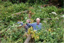
In summer 2005 the Group launched its programme of eradicating the invasive Himalayan Balsam from along the watercourse. At the time we were warned that this would take some time, advice that has proved correct. Nevertheless, good progress was made initially by moving year by year downstream from Rowledge. Wherever necessary permission was of course obtained to enter private properties to achieve this. Through the built-up area of The Bourne the problems faced with were mainly isolated clumps of the plant and we soon became aware of where the hot spots were. By 2009 we had progressed to the more heavily invaded final reaches of the Stream. There, with the agreement of the owner of Redhill House, a start was made but it soon became apparent that the Himalayan Balsam had spread not only along the banks of the stream valley but also right across the paddocks and up the hillside and into the woodland, almost reaching as far as Monks Walk. The dense masses of plants in the paddocks were quickly dealt with by the owner by mowing them with his tractor, but clearance along the streambed and up the hillsides on both sides required persistent hard graft by BCG. Each summer we have needed to revisit
the valley to deal with new clumps that spring up in this sector. Even so we can justly claim that the Bourne Valley is virtually clear of Himalayan Balsam. Unfortunately, a similar claim cannot be made for Japanese Knotweed, which is notoriously difficult to eradicate.
A Major Project
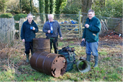
In December 2012, the dry winter allowed us to survey the state of the lower reaches of the Stream in more detail and a host of problems were encountered such as accumulations of litter and fallen trees blocking the water course. Fortuitously, at that precise time, an opportunity arose for us to bid for a substantial grant for a water-related project offered by South East Water. Our bid, based on the photographic survey carried out by Martin Angel which is shown at http://bourneconservation.org.uk/wp-content/uploads/2017/02/BourneStreamSurvey.pdf , was successful and an award of £2500 was made to clear the lower reach between Tilford Road and Waverley Lane. Christine King, Corporate Manager of the Company said “it was a unanimous decision by the panel of our Community Chest Fund to support this project, particularly as effective environmental management is at the heart of all our water supply operations and is embedded into all aspects of our work.” After due consideration and close scrutiny of the weather forecasts, we decided to implement the work at the earliest opportunity in February 2013.
The work was carried out in two phases. The first was clearance of the mass of litter that had accumulated along the stream bed which had been supplemented by a massive pile of fly-tipped rubbish dumped near the pumping station. By the end of the project four large skip loads had been taken away at our expense. The second phase was forestry work along the banks of the stream including clearance of the water course, pruning of many trees, lopping of dangerous branches and removal of some of the rhododendron and laurel in Monks Walk Wood. This was done in an environmentally friendly way, for example leaving many fallen trees as part of the natural woodland scene.
Biodiversity
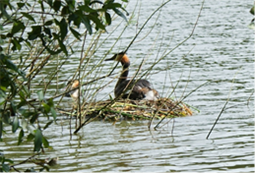
The Bourne Valley supports a varied range of plants and animals and is a vital corridor between the Surrey Hills AONB and Alice Holt Forest. The downstream flow of stream water intermittently contributes to the dispersal of species downstream, but there are barriers to the upstream migration of aquatic species even when there is flow. In the summer months the provision of alternative sources of water such as garden ponds, bird baths and farm troughs play a vital role in supporting wildlife in The Bourne valley.
Where the valley sides are too steep and unstable to be built on there are
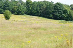
significant areas of woodland such as Monks Walk Wood, the Underdown Reserve and the two Burnt Hill Woods as well as many clumps of trees scattered along the valley and the footpath network. In places there is a preponderance of Scots Pine; these are non-native to the area but were introduced into it to provide poles for the hop fields of Farnham and were also widely planted in the post-WWII era. There are many good specimen trees most of which we have reported to the Woodland Trust. Ecological variety is provided by areas of grassland upstream in the Manley Bridge area and downstream in the Redhill House estate and Compton Fields. About half of the catchment area has been built over and so private gardens make an important contribution to biodiversity especially where the garden are managed with wildlife in mind. Gardens that are wildlife friendly can be just as visually attractive and low maintenance as those managed to win gardening competitions. On the north slope the Middle Bourne Lane Community Garden is managed by the Bourne Conservation Group to exemplify how a private garden can support a rich variety of wildlife. During a BioBlitz on a single very wet day in 2015 169 species of plant were identified (of which only 45 were garden plants) as well as 129 animal species. Over the past 6 years 264 species of moth have been found in that garden. In the Farnham-in-Bloom competitions this garden has consistently scored heavily on biodiversity for the Town.

Badgers and foxes are flagship mammal species along the valley. Badgers favour the sandy hillsides in which they can easily dig their setts and gain access to water when the Stream is flowing. Foxes thrive in the urban area where humans are always leaving food around. During the pandemic in 2020-21 roe deer and muntjac have been seen more frequently, and there are other species that do well such as slow worms and stag beetles.
The presence of numerous moth species is regarded as a sign of good sign of a healthy environment, and Dr Martin Angel’s monitoring has shown the presence of 800 moth species in The Bourne which is almost a third of the total number known in the UK. Notable records include regular catches of the Clifden non-pareil and pauper pug and 93 as well as other species listed as being of conservation concern by the Surrey Nature Partnership.
Recreational Walks
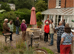
Over the years the Group has conducted many walks in South Farnham, as contributions to the Heritage Open Days sponsored each autumn by the Farnham Society and more recently as part of the summer Walking Festivals organised by Farnham Town Council. These have predominantly made use of the network of footpaths in The Bourne valley. The themes of these walks have included: George Sturt who lived in Vine Cottage, a grade 2 listed building near the stream and William Cobbett who was born in South Farnham and told of how he learned a lot about life by romping with his friends on the steep slopes of the valley, thought to be where the houses of Middle Bourne Lane now stand. Another unusual and popular theme was how water supply and drainage influenced the lives and health of local residents. This took in the borehole and the reservoir as well as pointing out the sewer system running beneath the valley floor.