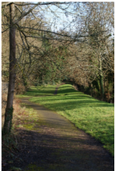
One of the attractive features of The Bourne area of South Farnham is the network of footpaths and bridleways that is greatly appreciated by ramblers, joggers and dog walkers as well as horse riders. It is part of the wider spread of Rights of Way that is the responsibility of Surrey County Council but is unique in having many of the paths signed with their distinctive local names. These are often associated with people who regularly used the path or lived nearby such as “Sturt Walk” linked to George Sturt who lived a few steps away in Vine Cottage.
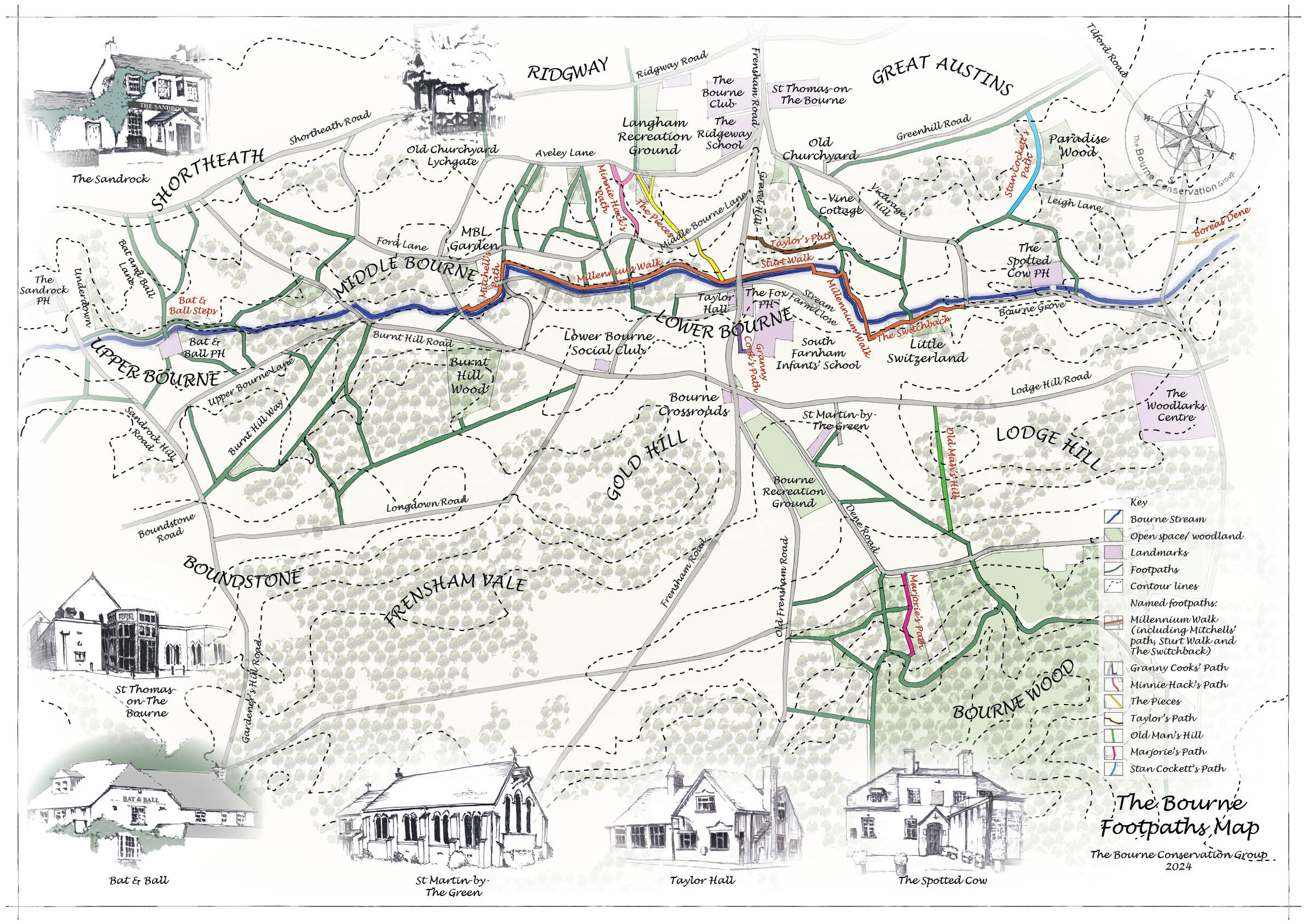
History
Archaeology has revealed that people were living in this area right back to the Stone Age and so it is likely that some of the paths are of very ancient origin. However, it can be said with greater certainty that a starting point for a more comprehensive network was the Roman era when there was a flourishing pottery industry in The Bourne and stretching across into Wrecclesham and Alice Holt Forest. Clearly, the movement of clay, products and customers would have necessitated good communications for people and animals. One later influence on the network was the advent of Farnham Castle and Waverley Abbey both of which generated much movement of people and supplies. In more recent times the network has evolved to enable the transport of gravel from the many pits in the area, and to support the widespread farming of hops. Also, until the advent of piped water in about 1900 there was a need for paths for residents to access the stream and springs to draw water in this predominantly dry area.
The Modern Network
Some of those activities took place in the Nineteenth Century which was a time of major change in the area including a steep rise in the population. That impacted on the older footways which became at first primitive roads, and eventually the tarmac corridors we know today.
Important milestones concerning the protection of footpaths were the Rights of Way Act of 1934 and the Access to the Countryside Act of 1949. The latter required Highways Authorities to register all public rights of way by compiling maps and statements. Surrey completed its Definitive Map and Statement (DMS) in 1952 and has maintained it under continuous review ever since. Copies of this for the whole of the county may be seen by appointment at the Merrow Lane Depot at Guildford or at the Surrey History Centre in Woking.
The Local Paths
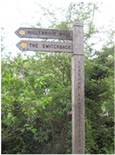
As part of the management system, all paths are allocated a number by the County Council for ease of reference. However, to mark the 20th Millennium, The Bourne Residents Association launched a successful project to define and sign a Millennium Walk along The Bourne Stream from Vicarage Hill in the East to Kiln Lane in the West. At the same time many of the adjacent paths were also signed with the names by which they were known locally. This Millennium Network is highlighted on the map accompanying this article.
The specially named paths are as follows:
Marjorie’s Path. Dr Marjorie Kuck for over 40 years campaigned vigorously and relentlessly to secure paths for the enjoyment of current and future generations. Without her dogged determination there would, for example, have been only two registered paths for public use as a right into Bourne Woods.
Old Man’s Hill. When the Bourne was bereft of trees the hill stood out like an old man’s bent back.
The Switchback. The hills and dips on this path as it goes past the wood called “Little Switzerland, explain the name.
Granny Cook’s Path. Named after a lady who lived at the top of the path near The Bourne School.
Sturt Walk. As previously mentioned this marks a walking route close to Vine Cottage, home of George Sturt for many years. It is highly likely he used it to go along to Stream Farm for fresh eggs or apples from their orchard.
Taylor’s Path. Retired Colonel Montague Wilbraham Taylor lived in the house called Averley Wood adjacent to this path. He founded the Community Centre now known as the Scout Hut.
The Pieces. This is an ancient path in two pieces from The Bourne Stream to Aveley Lane via Middle Bourne Lane.
Minnie Hack’s Path. Minnie Hack lived in one half of Rose Cottage (now a single dwelling) near the top of the path.
Mitchell’ Path. Severall generations of Mitchells lived in the adjacent small cottage now considerably extended and renamed Hunters Hollow.
Since the named network was opened in 2000, one extra path has been added as follows:
Stan Cockett’s Path. This runs through Paradise Wood and was named after the founder of The Bourne Conservation Group which started work in 2002. There is also a seat alongside the path with his name on it which was presented by the County Council to commemorate his local work.
Boreas Dene.
One other local path worthy of merit is the one running parallel to The Bourne Stream between Tilford Road and Waverley Lane. This is an ancient path that once linked farms along the valley and would almost certainly have been used by monks from Waverley Abbey. It is often called Boreas Dene.
Maintenance of the Network
Since 2002 The Bourne Conservation Group has worked with the County Council Footpath Officers to help maintain the network. This is a never ending and detailed task in which the Group takes great pride in carrying out but the Group always gives Full credit to the Residents Association for their creation of the signed Millennium network.
Problems
As this is a network in constant use there are always problems that must be dealt with for reasons of health and safety. In recent years these have ranged from a serious landslip and fallen trees to more mundane matters such as damaged posts or fingers, litter and graffiti.
Benefits of the Network
Many of the paths are used on a daily basis, for example by residents to get to work or by parents taking children to school.
There is also a more general usage of the paths for recreational walks and runs. This was highlighted during the Covid Pandemic when many more people than usual used the paths not only for daily exercise but also to explore parts of the area that had not previously visited.
The local network in The Bourne is of course a gateway to the wider network of paths in the Surrey Hills including onto the long distance North Downs Way and Greensands Walk both of which start in Farnham and are enjoyed by the more serious walkers.
Finally, for wildlife, the paths provide green corridors through the urban area of Farnham giving both connectivity and habitats for many species.
Sable Wood Steps
There are several steep paths leading down from the higher parts of the Bourne Valley to the lower, including those leading down to the Bourne Stream. Some of these have had steps laid over the years, which make walking easier. Periodically these steps have to be renovated – accumulations of autumn leaves need to be removed along with sand that has been washed down the paths during heavy rainfall.
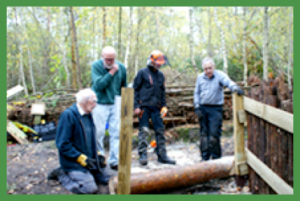
In places this soil erosion becomes so severe that that existing steps have to be re-built. In other places, new steps need to be built where none existed before. This happened recently in Sable Wood, the nature conservation area just off the Old Frensham Lane adjacent to the Bourne Woods. Walkers had complained to Bruce Callander, the owner, about the dangerous condition of one path in particular. As a result of erosion the path had become really hazardous. Bruce requested the help of BCG to build some new steps. The erosion from many years of rainfall running, had been exacerbated by the path’s heavy usage by dog walkers, but recently, more seriously, by mountain bikers enjoying the adrenalin rush of racing down the path. It was one of our more challenging projects. It took three days for our team of BCG members to help Bruce and his friends to emplace large logs – felled by Bruce – into position forming a flight of 14 steps. Each log needed to be securely fixed in position, and the step created infilled. The side tracks were fenced off to ensure walkers keep to the main path, and a gulley dug off the main bridleway to divert rainwater away from cascading down the footpath. The steps were finally finished off with a layer of scalpings provided by Surrey County Council and delivered by a team from Surrey Choices, a volunteer group of young people with learning difficulties who undertake outdoor work for SCC.
This was one of the more challenging jobs BCG has been asked to undertake – as the photograph confirms. However, it gave us a real sense of achievement in providing what should be a long-term solution to a problem that was fast becoming potentially serious.
How Can I Help?
Our footpath wardens regularly walk the paths in their area. However, we still have some paths around The Bourne area that do not have a footpath warden to look after them. If you are a Bourne resident or live near the Bourne and you are interested in volunteering to be a Footpath Warden, please contact the BCG Footpath Co-ordinator. But any help is appreciated, whether it is a simple phone call or email to the Footpath Co-ordinator to report a footpath problem you come across, or by regularly carrying a pair of pruners with you whenever you walk a path and cut back any invasive small branches that are starting to obstruct the path. Preferably, why not join our group and participate in some of our work sessions.
Contacts
BCG Footpath Co-ordinator
Clinton Bradshaw
Email info@bourneconservation.org.uk
SCC Countryside Access Asst.
John Baker
John.baker@surreycc.gov.uk